
BSA Troop 19 Grand Canyon Year 2000 Trip
|
||
Site Updated 04/13/2008
| BSA Troop 19 Grand Canyon Year 2000 Trip
Site Updated 04/13/2008 |
||||
|
OUR SITE
|
Weather Forecast GCNP |
|
Major Sites
GCHBA - promote, encourage and advocate the interests
of the hiking and backpacking community
in the regions of Grand Canyon.
Official and Unofficial Information - great place to start your search.
Premier Links Page (With FRAMES Browser)- (WITHOUT Frames) you could spend a day here - most still active, all from enthusiast. Some Home-style home pages with personal stories, others are more commercial - lots of cool photos of the areas that you might have missed, and places you've possibly been.
Maps and Directions
Trail Maps Specific to Troop 19 GCNP42K Trip
Corridor Map 7 5/8" x 9" @ 72 DPI 144K - RGB .JPG File
Corridor Map 17 3/4" x 21" @ 72 DPI 568K - RGB .JPG FileHermits Rest & Boucher Trail 9" x 10" 184K @ 72 DPI - RGB .JPEG File
Hermits Rest & Boucher Trail 17" x 20 1/2" 500K @ 72 DPI - RGB .JPEG FileHorseshoe Mesa Trail Map 9" x 9" @ 72 DPI 180K - RGB .JPG File South Bass Trail Map & Royal Arch Route Including Elves Chasm
9" x 7 1/4" @ 72 DPI 148K - RGB .JPEG File
South Bass Trail Map & Royal Arch Route Including Elves Chasm
Topographical Map of the Phanton Ranch / Clear Creek Section of the Grand Canyon
Official "Tourist" National Park Map. Restaurants, Gas Stations, Post Cards, Bathrooms . . and oh yes, CAMPSITES.
National Geography Maps - Looking for Topo Maps - browsing or buying, check out this site for all over the US.
Virtual Reality Camera set up on the South Rim?- visit it now!
VR view of the Grand Canyon from the South Rim. If you have a browser with a QTVR (Quick Time Virtual Reality Plug-in) like most MSIE, or Netscape v 2.x+ browsers, you can scan the canyon, zoom in, zoom out, and enjoy the view . . just like you were there. Need a QTVR? Follow the LINK.
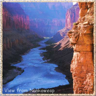
Photo GALLERY
Pictures contribued, or e-mailed to troop19BSA@aol.com - send your pix to us WITH a descrition for posting at this site.
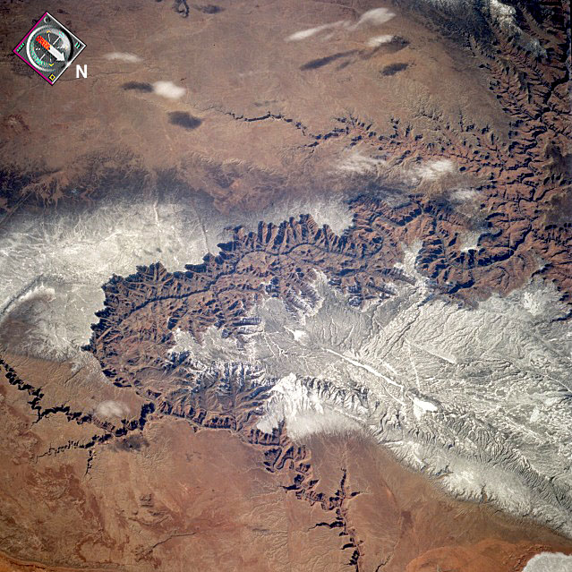
The Grand Canyon, one of the deepest canyons in the world with a depth of 1 mile (1.6 kilometers), can be seen in this spectacular, west-looking, low-oblique photograph. The snow-covered, forested Kaibab Plateau (north of the canyon) and the Coconino Plateau (south of the canyon) are visible. The western portions of the Painted Desert can be seen east of the canyon where the Little Colorado River joins the Colorado River.
Sweet Spot of the Canyon, great swimming hole high above the Colorado River. Ancient Anasazi Indian site (surrounded by petroglyphs) in Deer Creek Canyon (North Rim). Picture taken during the May '98 trip. Special thanks to Bob Preston.
Click on picture to see enlarged view.
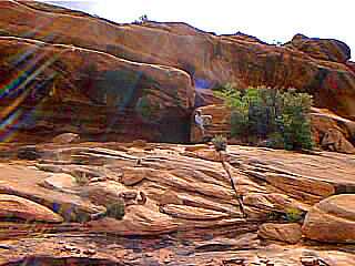
Hiking across the Esplanade, natural rock formations create caves and shelter for the night from the intense windy conditions that carve this natural rock garden.
Click on picture to see enlarged view.
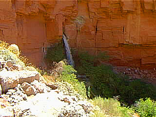
Upper Deer Creek Falls - an oasis tucked in the headwall of Deer Creek. This underground river bursts forth and falls 80 feet into the canyon floor - those white specks are hikers on the far wall.
Click on picture to see enlarged view.
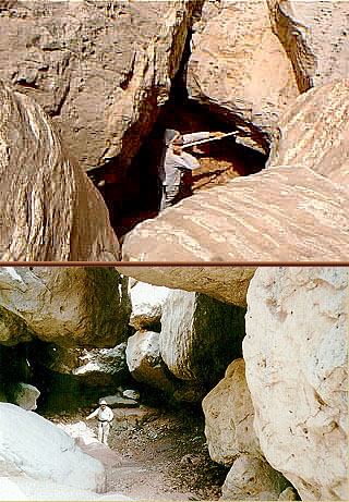
Hiking up a narrow canyon that has been blocked by a huge wall cave in. Negotiating through rock sections that are the size of garages, but look like pebbles in the canyon's eye view. Preston - Hayford 5/98
Click on picture to see enlarged view.
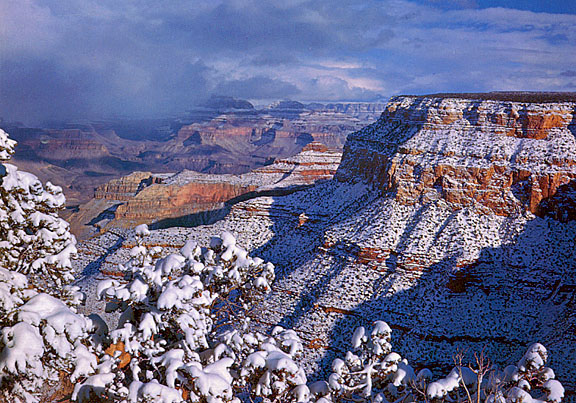
Snow storm sweeps across the canyon leaving mesas dusted in snow. View is from the South Rim, looking East. You can still feel the sense from the innercanyon from here.
Click on picture to see enlarged view.
HOW HIGH IS THE CANYON? Picture of looking down into the Grand Canyon at a rainbow BELOW you. View from the South Rim at a passing Summer shower.
Click on picture to see enlarged view.
Early Morning Sunrise looking east from Toroweap Overlook on the North Rim. Drop off to the river is over 2,700 feet, representing over 300 million years in exposed rock layers.
Click on picture to see enlarged view.
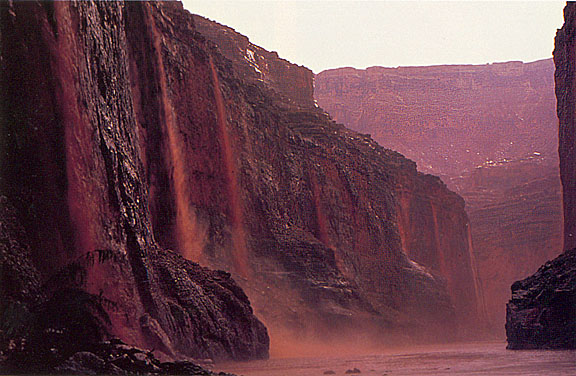
River view of storm run off - THE FINAL DROP some 1500+ feet in depth. Flash floods meet the Colorado River after traveling miles across the desert floor.
Click on picture to see enlarged view.
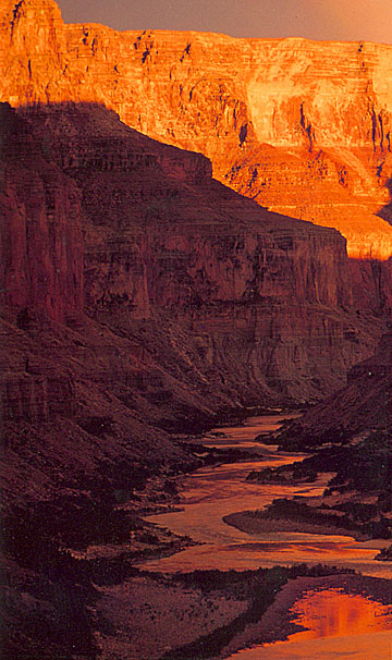
Sunset light bounces off a far wall and lights up an interior canyon, already absent of direct sunlight, but basking in the glow of a distant sun. Light, shade, water and desert the dichotomy of the Grand Canyon forces.
Click on picture to see enlarged view.
Great site highlighting postcards from yesteryear, illustrating the HERMITS TRAIL. If you have ever hiked this trail (or intend to) you would be interested in seeing what the trail looked like in it's heyday . . .it has changed a bit from the "Trail de luxe" as shown in these pictures.
Familiar with the Grand Canyon, Arizonia, and some of it's history? Here is a great PHOTO ARCHIVE that includes names and places that you will recognize. Very nice directory and search capabilities, enjoy your stay.
Been there, done that - trips into the canyon, learn from the experienced, visit with canyoneers.
Very Helpful Canyon Info Site - one of the best on the net - Visit with MIKE MAHANAY
Historical Background - the people and some pictures from the past
Backcountry Trip Reports, Various common and not-so-common trips
Grand Canyon Place Names - where did they come from - Alphabetic Format
Water Sources - Harveys' ReportMike Quinn's PHOTOGRAPHIC EXPLORATION - avid canyoneer site full of good information, history, canyon legends, and TRAIL DESCRIPTIONS. Great resource, especially if you are interested in Photography and the Canyon.
Visit Denise Traver's Beautiful and very informative website. Learn from a Grand Canyon Backcountry Ranger and GC Field Institue Instructor. Have some questions . . .here is a great person to ask - Denise Travers.
THIS PLACE IS COOL I WANT TO LIVE HERE ! - Okay now you can . . .live and work at the Grand Canyon, or any dozen of other National Parks. Free room and board, and lots of great places to visit. Check out COOLWORKS to get more information, or go directly to the Grand Canyon Job Description page and sign up.
Getting more serious?
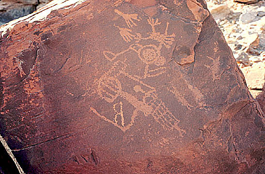
Imagine, you've just free climbed up an old washout, working your way deeper into a canyon that is REALLY out of the way, and you come across THIS. You're 2+ hours out of base camp, and you haven't seen signs of man since the first hour . . . . .You'd have to be NUMB or DUMB, not to have a chill run up your spine. Ancient petroglyphs, assumed to have been carved by Hopi Indians, long since moved on . . . but what were THEY doing here?
READING UP - where to get it, suggested books
This page is an index to books and other reference materials that are available on the Grand Canyon. Tremendous selection with direct links to Amazon.com - all orders made from links on this page earn up to15% for the Grand Canyon Trust.
Bob Ulrich's Recommended Reading List for Grand Canyon Visitors. Including hiking guides, road guides, and totebooks
ARIZONIA HIGHWAYS MAGAZINE - the infamous pictorial magazine about the southwest - on-line.
The Exploration of the Colorado River and Its Canyons (formerly titled: Canyons of the Colorado )John Wesley Powell, Dover, New York, 1895, reprint 1961
Grand Canyon Treks, by Harvey ButchartHiking in the Grand Canyon Backcountry (A no nonsense guide to Grand Canyon) J. D. Green, edited by Jim Ohlman
Best Easy Day Hikes - Grand Canyon, Ron Adkison , Falcon Publishing Company, Helena, Montana, 1998

